

Gorge Floor Trail
2.5 miles, round-trip | No soil, all rocks and boulders | Rated very difficult | No dogs allowed on this trail
Permits Required For Gorge Floor
- Free permits are required to access the gorge floor and can be obtained at the Interpretive Center. Visitors must wear proper footwear to obtain a permit—no flip-flops or crocs. Permits will not be issued after 4 p.m. (3 p.m. during daylight savings time)
- Permits limited to 100 per day. On busy days, permits may run out early in the morning. Permits are not transferable.
- Groups of 20 can get permits on Saturday and Sunday only. Groups of 30 can get permits Monday through Friday only. To protect the natural resource, no groups larger than 30 are allowed.
- Weather and water flow conditions can restrict gorge floor access.
Stoneplace Trail
Approximately 10 miles, round-trip | Rocky and compacted red dirt | Rated moderate to difficult
- Accessed on Interpretive Center Road.
- Trail is approximately 10 miles round-trip or 15 miles if you include the High Bluff Loop.
- Must obtain permit at the Interpretive Center.
- This trail is also used for mountain biking.
- It consists of an old road bed with large ruts in several areas.
- During hunting season, it is recommended hikers and bikers wear brightly colored clothing.
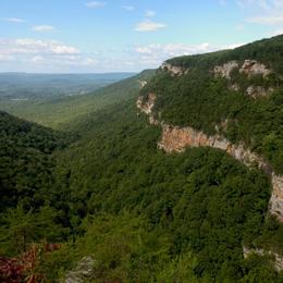
North & South Rim Trails
3 miles, round-trip | Mulched surface with exposed roots | Rated moderate
The North and South Rim Trails consist of 3 miles round-trip which will take approximately 2 hours to hike. It is a mulched trail with exposed roots that is a leisurely walk. From the Interpretive Center there is a recycled rubber tire trail that accesses Overlooks 2 and 3.
North Rim Trail
Access this trail behind Interpretive Center. It is approximately 3/4-mile one-way, moderate with some inclines and stairs. This trail has five Scenic Overlooks described below:
- Best southern view into the gorge. Oceana Falls is below, with Bridal Veil Falls at the far end of the gorge. Tightrope walker Karl Wallenda walked from this overlook to his tower on the south rim in 1970. Another aerialist, Professor Leon, made a similar walk from the north to the south rim in 1886. Gorge depth is 750 feet.
- View of L’Eau d’Or (pronounced Ladore) Falls, top of Tempesta Falls, and Hawthorne Cascade and Pool. Gorge depth is 350 feet.
- View of L’Eau d’Or Falls, Hawthorne Pool, and remains of a water compressor plant used in building Tallulah Falls Dam.
- Good view of Tallulah Falls Dam (completed in 1913) and upper portions of the gorge.
- View of upper gorge and southern view to Hawthorne Pool and Overlooks 2 and 3. Gorge depth is 250 feet.
South Rim Trail
Located on the opposite side of the gorge from the Interpretive Center and is approximately 3/4-mile one-way, moderate with inclines. This trail has five Scenic Overlooks described below:
- View of Hawthorne Pool, North Rim Trail Overlooks 2 and 3, top of Tempesta Falls and down gorge towards Hurricane Falls. Gorge depth is 350 feet.
- View of Hawthorne Pool, Tempesta Falls and Pool. Gorge depth is 400 feet.
- View of Hurricane Falls and Pool, “Devil’s Pulpit” outcrop below, and the Interpretive Center is across the gorge. Gorge depth is 500 feet.
- View of Hurricane Falls, Oceana Falls, Caledonia Cascade (600 feet), and North Rim Overlook 1. Gorge depth is 650 feet.
- View of Caledonia Cascade and the Wallenda north tower area. Bluff to far right is approximately 1,000 feet high.
Hurricane Falls Loop Trail
Approximately 2 miles, round-trip | Mulched with metal stairs | Rated difficult
- This trail has a total of 1,099 stairs (including staircase to gorge floor).
- Please do not attempt this trail if you have any known health condition.
- Please do not leave children unattended.
- No pets allowed on this trail.
High Bluff Trail
4 miles, round-trip | Compacted red dirt | Rated moderate
- Must obtain permit at the Interpretive Center.
- This trail is also used for mountain biking.
- During hunting season, it is recommended hikers and bikers wear brightly colored clothing.
Bill and Dustie MacKay Trail (Formerly 'Shortline Trail')
3 miles | Paved | Rated easy
This trail can be accessed from Terrora Circle Road, is paved and can be used for hiking, biking, skating, etc. It follows part of an old railroad bed.