


Parking for trails can be located at the parking lot across from the visitor’s center.
Byron Herbert Reece Trail
Access the Byron Herbert Reece Nature Trail from the Backcountry Trailhead located near the campground. Follow the green access trail blazes 0.1 mile mark to the trail intersection marked with white blazing. The ‘BHR’ trail loops from this location through a diverse forest that has more types of trees than those that grow in Yellowstone National Park. Wildflowers abound during warmer months.
- Length: 0.8 mile partial loop
- Difficulty: easy
- Average Travel Time: 1 hour
- Surface: natural
- Uses: walking, foot traffic only
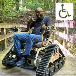
- Accessibility: limited
Coosa Backcountry Trail
Beginning at the Backcountry Trailhead, follow the green-blazed access trail to where the green-blazed Coosa Backcountry Trail begins its loop up and over the summit of Duncan Ridge and connection can be made with several trails in the Chattahoochee National Forest. Hikers will climb and descend over 1 mile in elevation, crossing 3 ridgelines. Please read the precautions for the Bear Hair Gap.
- Length: 12.9 mile partial loop
- Difficulty: moderate
- Average Travel Time: 9 hours
- Surface: natural
- Uses: walking, foot traffic only
- Accessibility: limited
Bear Hair Gap Trail
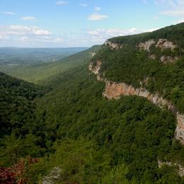
Beginning at the Backcountry Trailhead, follow the green-blazed access trail to where the green-blazed Bear Hair Gap Trail begins its nearly 4 mile loop up and over the lower ridges of Blood Mountain . Wildflowers abound in season and long-distance vistas can be seen after the leaves have fallen. The trail leaves the park and travels onto the Chattahoochee National Forest which is open to hunting. It is advisable to wear bright colored clothing, other than white or safety orange vests during hunting season.
- Length: 4.1 mile partial loop
- Difficulty: moderate
- Average Travel Time: 2 hours
- Surface: natural
- Uses: walking, foot traffic only
- Accessibility: limited
Trahlyta Lake Trail
The trail around Lake Trahlyta can be accessed from picnic shelter #2 or cabin #35. The trail crosses an earthen damn constructed by the CCC in 1935. A spur trail off the damn leads to an observation deck below the dam’s spillway. One of the more photographed views in North Georgia is of Blood and Slaughter Mountain taken from the bridge over the dam spillway. This is an easy walk.
- Length: 1 mile loop
- Difficulty: easy
- Average Travel Time: 1 hour
- Surface: natural and paved
- Uses: foot traffic only
- Accessibility: Partial
Reece Farm Heritage Trail
The Reece Farm Heritage Trail can be accessed by taking the Lake Trahlyta Trail. The trail splits off at the water treatment facility on the backside of the lake. The trail ends at the Reece Farm Heritage Center.
- Length: 1.5 mile trail
- Difficulty: moderate
- Average Travel Time: 1 hour
- Surface: natural
- Uses: foot traffic only
- Accessibility: limited
Backcountry Trails & Camping
Backcountry camping is allowed on the Coosa Trail by permit. Sites are available on a first come-first served basis.
Rangers can and will cite violators disregarding rules and regulations or damaging our resources. To help preserve our natural and cultural resources and their beauty and uniqueness for others to enjoy, we encourage low-impact practices:
- Pack it In, Pack it Out.
- Take only Pictures and Memories, Leave only Footprints.
Backcountry trails cross over several streams and nearby to other water sources, purity of these water sources cannot be guaranteed, and it is advisable to treat any water collected from these before using.
The backcountry area is wild and remote. To be safe, always be aware of your surroundings. For example, do not camp beneath standing dead trees or trees with dead branches. Be aware of rapidly changing weather conditions, not just cold or wet; but also of the dangers of heat and lightning. Be wary of poisonous plants, stinging and biting insects, snakes, and other animals. Be ‘bear-safe,’ carry a food storage bag and rope to hang packs and food supplies. Even a dog that has become separated from its owner can ruin a trip by eating unprotected food supplies.
When possible, travel with a friend, or better yet, friends. At the least, leave an itinerary with someone you can trust and who will send help, should you become incapacitated or overdue. Cellular telephones should not be depended upon in mountainous terrain. Always allow adequate time to make your journey, and never wander off of marked trails. Criminal trespass charges and search and rescue costs can be charged to persons guilty of negligence or failing to get user permits (OCGA 12-3-10).
Other Information
For any questions, visit the Visitor Center or call us at 706.745.2628.